Conventional signs and designations on geographical maps. Conventional signs Conventional signs by
Declassified topographic maps of the General Staff of the USSR are freely circulating on the Internet. We all love to download them, look at them, and often print them on sheets of paper for further use for their intended purpose - i.e. go hiking with them.
Topographic maps of the General Staff are the most accurate and best. Any other purchased maps printed in modern times will not carry as much accuracy and specificity. The symbols and symbols on the topographic maps of the General Staff are much more complex than any other symbols on maps purchased in the store. We all remember them from geography lessons at school.
As an experienced user of such maps, I would like to describe at the beginning of this article the most important, in my opinion, designations. If the rest are more or less understandable, since they are almost all identical to other types of cards (not the General Staff), then these are something new and still incomprehensible. Actually, I will start with the symbols of rivers, fords, forests and roads.
Rivers and water resources
| Speed and direction of river flow (0.6 m/s) | |
|
Characteristics of rivers and canals: 30 - Width (m), 0,8 - Depth (m), TO- Soil type ( TO - rocky, P - sand, T - solid, IN - viscous) |
 |
| Water line mark, shore height above sea level (393m) |  |
| Brody: 0,3 - depth, 10 - length, TO- rocky soil, 1,0 - speed (m/sec) |  |
| The swamp is passable |  |
| The swamp is impassable |  |
| Characteristics of bridges: D- construction material ( D - wood, TO - stone, reinforced concrete - reinforced concrete), 43 - length of the bridge, 4 - width of the roadway (m), 10 - load capacity in tons |  |
| Forest clearing and width in meters (2m) |  |
| Field and forest roads |  |
| Winter road, a functioning road only in the winter season, during the cold period. Can go through swamps. |  |
| Dirt road, 6 - width of the roadway in meters |  |
| Gat - a road with a wooden surface, a flooring made of logs, 3 - width of the roadway |  |
| Go away |  |
| Railway track |  |
| Gas pipeline |  |
| Power lines (PTL) |  |
| Dismantled railway |  |
| Single track railway, narrow gauge. Also railway bridge |  |
| Highway: 6 —width of the covered part, 8 — the width of the entire road from ditch to ditch in meters; SCH- coating material ( B - cobblestone, G - gravel, TO - crushed stone, Shl - slag, SCH - crushed stone) |  |
Relief
| Steep river banks, rocky outcrops, Parma |  |
| Relief contours with relative height designation (260 m) |  |
| Mountainous area without vegetation cover, covered with kurum stones and rock outcrops |  |
| Mountainous area with vegetation cover and sparse trees, the forest border is visible |  |
| Outlier rocks with a height in meters |  |
| Glaciers |  |
| Rocks and rocky cliffs |  |
| Elevation mark (479.2 m) |  |
| Steppe region. Near the edge of the forest |  |
| Sands, deserts |  |
Photos of some geographical objects


The main winter road laid through the taiga forest. In summer there are thickets here (Yakutia)

Forest dirt road (Ivdel district, Northern Urals)

Gat - road with wooden covering (Lobnensky forest park, Moscow region)

Rock outcrop, Parma (Stone "Giant", Middle Urals)

Remnant rocks (Old Stone rock, Middle Urals)
It should be understood that all available topographic maps of the USSR General Staff have long been outdated. The information contained on them can date back to the 70-80s of the last century. If you are interested in the details of walking along certain trails, roads, the presence of settlements and geographical objects, then you should check in advance the reliability of the information from other sources. There may no longer be any paths or roads at all. Small settlements can be abandoned and look like wastelands, often already overgrown with young growth.
But, in any case, the maps of the General Staff still provide more accurate information, and using them you can more productively calculate your route and distance. In this article, I did not bother your heads with unnecessary symbols and symbols of topographic maps. I have posted only the most important and significant for the mountain-taiga and steppe region. Those interested in details can take a look.
Maps of the USSR General Staff were made using the Soviet system of layout and nomenclature of topographic maps. This system is still used in the Russian Federation and some former Soviet republics. There are newer maps, the state of the terrain on which is approximately 60-80s of the last century, and older maps, the so-called General Staff of the Red Army, made by geodetic reconnaissance of the pre-war period. “The maps are compiled in a conformal transverse cylindrical Gauss-Kruger projection, calculated using the parameters of the Krasovsky ellipsoid for a six-degree zone,” - and if you don’t understand, it doesn’t matter! The main thing is to remember (or write down, save this article) the points that I cited above. Knowing them, you can skillfully use maps and plan your route without using GPS.
A topographic map on which the tactical or special situation with all its changes during combat operations is graphically displayed using conventional tactical signs with the necessary explanatory inscriptions is called the commander’s working map.
The process of displaying a tactical or special situation on a map or other graphic document is called “drawing the situation.” The set of conventional tactical signs is called “tactical situation” or “situation” for short.
Completeness of application of the situation:
1. About the enemy:
- location of weapons of mass destruction with detail down to an individual weapon or missile launcher;
- infantry, motorized infantry, tank, artillery units with details down to platoon, gun;
- radiation situation to the extent necessary for work.
2.About your troops:
- the position of units with detail two levels below their level (for example, the regiment commander applies the signs of battalions and companies).
- tasks assigned by the senior manager.
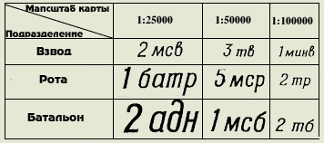
Applicable topographic maps:
- 1:25000 - commanders of units and companies;
- 1:50000 - battalion commanders;
- 1:100000 - commanders of regiments, divisions, corps;
- 1:200000 - commanders of armies, fronts;
- 1:500000 - overview maps of the fronts, the main command.
The following colors are used to apply the furnishings:
- Basic - red, blue, black;
- Auxiliary - brown, green, yellow.
The use of other colors, as well as shades of primary or secondary colors, is not permitted.
- RED used to designate for our troops the position, tasks, actions, weapons and equipment of motorized rifle, airborne, tank, aviation, and naval units. The same color indicates fire zones, regardless of who created these zones.
- BLUE used to designate for enemy troops the position, tasks, actions, weapons and equipment of all types of troops. Also, all inscriptions related to the enemy are written in this color. The same color indicates flood zones, regardless of who created these zones.
- BLACK used in designation for our troops positions, tasks, actions, weapons and equipment of the missile forces, artillery, anti-aircraft troops, engineering troops, chemical troops, radio engineering troops, communications troops, railway and other special troops. Also, all inscriptions relating to all branches of our troops are made in this color.
- BROWN used for drawing roads, routes, column tracks of our troops, filling zones of use of bacteriological (biological) weapons, marking the outer border of the radioactive contamination zone V.
- GREEN used to mark the outer boundary of the radioactive contamination zone B.
- YELLOW used to fill the zone of chemical contamination.
All inscriptions are made in straight or oblique standard drawing font. Straight font is used for the map title and official signatures. In other cases, italic font is used (inclination angle 75 degrees). Italic capital letters are used for official headings and signatures, as well as at the beginning of sentences and for abbreviations. Lowercase letters are used to write legends, explanatory notes and a large number of abbreviations. All inscriptions are made only horizontally. Vertical or slanted lettering is not permitted.
The size of the inscriptions should be proportional to the scale of the map and commensurate with the importance of the unit. The table shows the sizes of the inscriptions depending on the scale of the map and the unit (life-size shoif size). The font size for designating smaller units, individual objects, and explanatory inscriptions cannot be larger than the font size for the platoon.
Drawings of tactical signs of our troops are always directed towards the enemy and vice versa. The exception is anti-aircraft weapons, which are always directed towards the top edge of the map.
If the tactical sign is clearly larger in size than the true size of the object on the map scale, then the location of the object on the ground is considered to be the center of the tactical sign (for flags, the lower part of the flag stem, for arrows, the front end of the arrow).
Control rooms and communications
The regiment control center is in place. The inscription KP means command post, TPU means rear control post. The inscription inside the flag is the regiment number.
Battalion control center. The inscription 1/10 MSP means 1 battalion of the 10th motorized rifle regiment.
The same is true in motion.
1- The company commander’s command and observation post is in place. 2- BMP of the company commander (accordingly designated as an armored personnel carrier, the tank of the company commander. The tactical sign of this type of equipment and two dashes are placed. The platoon commander has one dash.
Observation point of the 10th motorized rifle regiment. If there is a letter inside the sign, this means that the NP is specialized (A-artillery, I-engineering, X-chemical, B-air surveillance, T-technical). In artillery and special forces the badge is black.
Traffic control post (P-regulator, checkpoint-checkpoint, KTP-control-technical point.
Communication center. 1- field mobile. 2- stationary
Radio. 305 - brand of receiver.
Radio station. 1-movable, 2-wearable. 3-tank
Mobile radio relay station
Radar reconnaissance station. 1- air targets. 2 ground targets.
Radio network of portable stations.
Radio direction of mobile stations.
March, reconnaissance and security
1-Pedestrian column of troops. A regiment with a number designation, a battalion with three lines, a company with two lines, a platoon with one line, a squad without lines.
2. Column of troops on equipment. There are 2 MSRs on BMPs here. if there is a tank column, then the tank icon, if there is an armored personnel carrier column, then the armored personnel carrier icon, etc.
1- Column of special troops. Here is the fifth engineer battalion.
2-Column of an artillery battalion (battery - two dashes, platoon - one dash, separate gun on the march - the arrow is shorter and without dashes
The head marching outpost consisting of the first motorized rifle company on an infantry fighting vehicle, reinforced by the first platoon of the second tank company (BPZ - side marching outpost, TPZ - rear.
Mobile obstacle detachment of the tenth motorized rifle regiment.
Column of a logistics support platoon (vob), if the company is mated. support then the inscription - rmob, battalion mob
Column of the technical closure of the battalion (P-regiment).
Reconnaissance squad.
Patrol squad on an infantry fighting vehicle
 Combat reconnaissance patrol of the 2nd tank battalion by 9.00 on November 15. (ORD-separate reconnaissance patrol, RD - reconnaissance patrol, OFRD - officer reconnaissance patrol, IRD-engineer reconnaissance patrol, KRD - chemical reconnaissance patrol), Color of the badge by branch of the military.
Foot patrol.
Foot patrol of the 7th tank company and its patrol route
1 platoon of reconnaissance company of the 10th motorized rifle regiment in search (raid)
1st platoon of the 9th tank company in an ambush.
Location and actions of units
The area (section of terrain) occupied by the unit. There are 3 motorized rifle battalions here. The inscription indicating the unit is required, the tactical sign of the unit's equipment is optional. The sign is large-scale; on the map it covers the entire area occupied by the unit. A broken line indicates that the area is targeted for occupation by the unit. The letter "L" indicates that this is a false area.
An area occupied by a unit whose tactical color is black. This is the area of the 5th engineer battalion.
The direction of the unit's advance.
The unit's immediate task. Here 1 is the general sign of a battalion (as indicated by three dashes on the arrow), 2 is a battalion on an infantry fighting vehicle. If the battalion or company, or platoon is tank, then tank badges, if on an armored personnel carrier, then armored personnel carrier badges, if the battalion is on foot, then sign No. 1 is used. The sign is large-scale!
Follow up task. Here 1 is the general badge of the battalion, 2 is the badge of the tank battalion. The sign is large!
The position (milestone) reached by a unit by a certain time. The sign is large.
A machine gun platoon in battle formation. Below is the general sign of the battalion and company on an infantry fighting vehicle. The sign is large.
The line of probable meeting with the enemy.
Initial line (regulatory line, line of entry into battle of the second echelon, etc. lines
Front (line) occupied by units. Line of contact with the enemy
Deployment line in battalion columns (company - two lines, platoon - one line)
Line of transition to attack. 1 general sign, 2 motorized rifle units.
Dismounting line for motorized rifle units
Firing line of a tank unit. Here is the third firing line of the third tank battalion.
Anti-tank unit deployment line
Mining frontier.
Tactical airborne landing area. Here is the second battalion of the third motorized rifle regiment. disembarkation is expected at 9.00 on July 10. If the landing has taken place, then the line is solid.
Helicopter landing area.
Naval landing site and points.
The unit was stopped at this point.
The unit's withdrawal from the occupied line.
Demarcation line between shelves
dividing line between battalions.
A line (position) not occupied by units.
The location of the unit in defense.
1 - general badge, 2 - motorized rifle unit.
 The place where the prisoner was captured. Here a soldier of the second battalion of the 26th infantry regiment of the 19th mechanized division was captured at 5.00 on August 12.
The place where the documents of the murdered person were seized.
Weapons of mass destruction and protection against them
Our planned nuclear strike. 015 - target number, 1/5 order - first battery of the fifth cancer division. -40 - ammunition power 40 kilotons, B - air explosion. "H+1.10 - explosion time.
Safe removal line (protrusions towards the explosion).
An area of destruction from an enemy explosion. The inner ring is a zone of complete destruction, then a zone of continuous rubble and weak destruction; the outer ring is a zone of neutron influence on openly located personnel.
Fire area and direction of fire spread.
The location of a nuclear explosion carried out by the enemy, indicating the type of explosion, power and time, and the zone of radioactive contamination. The direction and sizes of the zones are large-scale
Radiation level measuring point with level indication. time and date of infection.
Enemy nuclear mine with indication of charge power, laying depth and detection time.
Field of chemical landmines.
The area contaminated with toxic substances and the direction of displacement of the agent cloud.
Biological weapons contamination site.
Small arms and artillery
Light machine gun
Heavy machine gun
Anti-tank hand grenade launcher
Automatic grenade launcher
Anti-aircraft missile system.
Anti-aircraft machine gun installation
Easel anti-tank grenade launcher
Man-portable anti-tank missile systems (ATGM). Here is 1 - ATGM of an anti-tank machine gun platoon, 2 - ATGM of an anti-tank platoon.
Flamethrowers. Here 1-reactive light, 2-reactive heavy.
Anti-tank gun. 1 - general designation, 2 - up to 85 mm, 3 - up to 100 mm, 4 - more than 100 mm.
A gun. 1 - general designation, 2 - up to 100 mm, 3 - up to 152 mm, 4 - more than 152 mm.
Howitzer. 1 - general designation, 2 - up to 122 mm, 3 - up to 155 mm, 4 - more than 155 mm.
Howitzer with a caliber of over 155mm, firing nuclear ammunition.
Self-propelled howitzer. Here the caliber is up to 122 mm.
Rocket artillery combat vehicle. 1-general designation. 2 - medium caliber.
Mortar. 1 - general designation, 2 - small caliber, 3 - medium caliber, 4 - large caliber.
Anti-aircraft gun. 1-general designation. 2-small caliber, 3-medium caliber.
Anti-aircraft self-propelled gun. 1 - without radar, 2 - with radar.
Anti-aircraft missile system combat vehicle. The style of the sign depends on the type of base vehicle, the icon inside depends on the type of rocket.
Anti-aircraft missile launcher. 1-short range. 2-short range, 3-medium range. The sign in the circle is the Zen.PU battery.
Area of artillery division firing positions. Here is the first division of the 12th artillery regiment. Battery signs are out-of-scale, area-scale.
Battery firing position 100mm. guns.
Mortar battery firing position
A separate goal. 28 is the target number. The blue sign inside the circle is the location of the enemy fire weapon.
Fire concentration areas. Numbers are CO numbers. The signs are large.
A single stationary barrage light indicating its conventional name.
Deep, stationary barrage fire on three lines indicating the code name Co and line numbers.
Single moving barrage light indicating its conventional name and line numbers.
Double moving barrage fire
Sequential concentration of fire indicating the conventional names of the lines and target numbers (solid lines indicate the lines at which it is planned to fire simultaneously; with double PSO, solid lines connect targets on two lines, with triple on three. lines and areas of targets are large-scale.
 Massive fire indicating its conventional name and section numbers.
Fire shaft indicating the conventional names of lines, sections for divisions and their numbers, and numbers of intermediate lines.
Boundary line of the firing sector
Boundary line of the additional firing sector.
Concentrated fire from a motorized rifle company (SO-1 - section number, 1,2,3 - platoon section numbers.
The barrage line of a grenade launcher platoon with its number and sections of squad fires indicated.
Armored vehicles, cars and helicopters
Tank. 1 - general designation, 2 - battalion commander's tank, 3 - amphibious tank, 4 - flamethrower tank
A tank with a complex of anti-tank weapons.
Tank and infantry fighting vehicle with mine trawl
Tank with BTU
Tank with STU
Combat reconnaissance vehicle and combat reconnaissance patrol vehicle (BRDM)
Car and car with trailer
1-tank tractor, 2-track tractor, 3-car tractor
Motorbike
Sanitary vehicle
Helicopter. 1 - general designation, 2 - combat, 3 - transport.
Engineering equipment and structures
Tank bridge layer
Crawler floating conveyor
Crawler self-propelled ferry (ferry-bridge vehicle).
Engineering equipment on a wheel base (Here is a heavy mechanized bridge TMM)
Engineering equipment on a tracked base (here BAT).
Pontoon-bridge park with an indication of its type.
Trench of a motorized rifle unit with a closed gap
Trench with communication progress.
A gun in a trench. The color of the trench sign according to the type of troops. (same sign for all mobile fire weapons)
An open type observation structure (closed type with a black filled triangle.
Shelter for vehicles (vehicle icon by type)
Shelter indicating the degree of protection and capacity
Open gap
Covered gap
Scarp (counter-scarp) indicating the length.
Inconspicuous wire fence (spiral, net on low posts.
Anti-tank ditch indicating its length.
Notches indicating the type, number of rows and length.
Mined obstruction indicating its extent.
Wire fence (number of lines - number of rows).
section of hedgehog fences indicating the number of rows and length
Anti-tank minefield
Anti-personnel minefield (a mixed minefield is indicated by alternating filled and open circles)
Minefields installed by means of remote mining.
1-uncontrolled land mine, 2-radio-controlled land mine, 3-wire-controlled land mine.
Passage in barriers indicating the number and width.
Bridge destroyed by the enemy
A section of road destroyed by the enemy, indicating the extent of the destruction.
Landing crossing indicating the number and type of landing craft.
Crossing tanks under water indicating 3-depth, 180-width of the river, 40-width of the route, P-character of the bottom, 0.8-current speed.
Ferry crossing indicating the number of ferries, their capacity and type of fleet
Ferry crossing consisting of three GSP ferries and 3 ferries of 40 tons each and from PMM vehicles.
Bridge on rigid supports. H-low-water 120m long, 4m wide. and a lifting capacity of 60 tons.
Pontoon bridge 120m long, with a load capacity of 60 tons from the PMP park
The ford is 0.8 m deep, the river width is 120 m, the bottom is solid, the flow speed is 0.5 m per second.
Ice crossing number five for loads of 60 tons.
Technical support and logistics units and their facilities
Collection point for damaged vehicles. P-regimental, 1 - its number, bt - for armored vehicles
Repair and evacuation group on an armored personnel carrier. P-regimental, BT - for armored vehicles.
Regimental warehouse. G - fuel, 10tp - tenth tank regiment.
Regimental medical station.
Battalion medical center.
Company medical post
Shooter-medic.
Ambulance transport post
Battalion fuel and lubricant refueling point
Battalion supply point
Company ammunition supply point
Service point along the route. G-GSM.
Combined arms units and subdivisions
- Motorized rifle. regiment, battalion, company, platoon, squad - smp, sb, msr, msv, mso
- Tank regiment, battalion, company, platoon tp, tb, tr, tv
- Machine gun artillery battalion, company pullab, pular
- Parachute battalion, company, platoon pdb, pdr, pdv
- Airborne assault battalion, company, platoon dshb, dshr, dshv
- Reconnaissance company, platoon, section rr, rv, ro
- Machine gun company, platoon, squad - pull, pull, pullo
- Anti-tank platoon- PTV
- Grenade launcher platoon, squad- guards, th
- Anti-tank machine gun platoon ptpulv
Artillery units and units
- Artillery regiment, division, battery - ap, adn, batr
- Self-propelled artillery division, battery sadn, sabatr
- Battery of anti-tank guided missiles - batr ATGM
- Mortar battery, platoon- minbatr, minv
- Control platoon- woo
Air defense units and units
- Anti-aircraft missile battery, platoon, squad - zrbatr, zrv, zro
- Anti-aircraft artillery battery, platoon, squad - zabatr, manager, zo
- Anti-aircraft missile and artillery battery - earner
- Battery, platoon of anti-aircraft self-propelled guns - battalion ZSU, airborne ZSU
Special Forces Units
- Engineer-sapper company, platoon, squad- isr, isv, iso
- Engineer assault company, platoon, squad - ishr, ishv, isho
- Airborne transfer company- pdesr
- Pontoon company, platoon- Mon, Mon
- Platoon, squad of tracked amphibious transporters - up GPT, dept. GPT
- Platoon, squad of tracked self-propelled ferries - up GSP, dept. SHG
- Bridge laying department - dept. MTU
- Company, chemical defense platoon - rkhz, vkhz
- Platoon, radiation and chemical reconnaissance department - vrhr, orhr
- Platoon, special processing department - soo, oso
- Flamethrower platoon, squad- ov, oh
- Company, platoon, communications department - rs, sun, os
- Commandant's company, platoon- kr, kv
Technical support and logistics units
- Separate battalion, logistics company - omo, omo
- Automobile company, platoon, squad - avtr, avtv, auto
- Repair company- remr
- Economic platoon, department- household, household
- Supply platoon, supply platoon- vob, vsn
- Maintenance department- oto
Control points
- Command post- KP
- Rear control center - TPU
- Command observation post- KNP
- Reserve command post - ZKP
- Observation post- NP
- Air surveillance post- PVN
- Artillery observation post- ANP
- Technical supervision point - PTN
- Engineering observation post INP
General terminology
- Vanguard (rearguard) - Av (Ar)
- Bacteriological (biological) weapons - BO
- Bacteriological (biological) infection - BZ
- Battalion refueling point - BZP
- Fighting machine- BM
- Infantry fighting vehicle- BMP
- Combat reconnaissance vehicle- BRM
- Combat reconnaissance patrol vehicle- BRDM
- Side marching outpost- BPZ
- Armored personnel carrier- armored personnel carrier
- Combat kit- bk.
- Explosives- BB
- Height- high
- Head marching outpost- GPZ
- Head watch- GD
- Diesel fuel- DT
- Long-term fire structure (long-term fortification structure) - DOS (DFS)
- Incendiary weapons (incendiary weapons) - ZZhO (ZZhS)
- Refueling- lock
- Protection against weapons of mass destruction - ZOMP
- Zone of radioactive, chemical, bacteriological (biological) contamination - ZRZ, 3X3, ZBZ
- Anti-aircraft self-propelled gun - ZSU
- Starting line (starting point) - ref. r-zh, (ref.p.)
- Kiloton- CT
- Command and staff vehicle - KShM
- Set- set
- Commander of the 1st motorized rifle, 2nd tank battalion - KMSB-1, KTB-2
- Commander of the 1st motorized rifle, 2nd tank company - kmsr-1, ktr-2
- Commander of the 1st motorized rifle, 2nd tank platoon - kmsv-1, ktv-2
- Mine-explosive barrier- Cost center
- Regimental medical station MPP
- Battalion medical center MPB
- Company medical post MPR
- Emergency ration- NZ
- Irreducible stock - NHS
- Firing position- OP
- Outskirts- env.
- Toxic substances (persistent toxic substances, unstable toxic substances) - 0V (COV, NOW)
- Mark- Elevation
- Separate- dept.
- Advance detachment- BY
- Mobile barrage detachment - POS
- Field refueling point - PZP
- Consecutive concentration of fire - PSO
- Enemy- pr-k
- Air defense (anti-tank defense) - Air defense (PTO)
- Anti-personnel minefield PPMP
- Anti-tank minefield PTMP
- Anti-tank reserve- PTRez.
- Radioactive contamination- RZ
- Radioactive substances- RV
- Radiation and chemical reconnaissance - RHR
- Reconnaissance squad- RO
- Dividing line- boundary line
- Radio network (radio direction) - r/s (r/n)
- Area- district
- Repair and evacuation group (repair group) - REG (Rem. G)
- Regulation boundary (regulation point) - r-j per. (p. per.)
- Collection point for damaged vehicles - SPPM
- Sentry detachment (outpost, outpost) - Art.O (Art.Z, Art.P)
- North, south, east, west - north, south, east, west
- North-west, north-east, west, south-east south-west- north-west, north-east, south-east, south-west
- Focused Fire - CO
- Daily dacha- s/d
- Tactical airborne assault Tact. VD
- Tank bridge layer - MTU
- Rear marching outpost - TPZ
- Communication center- mustache
- Fortified area- UR
- Chemical observation post HNP
- Chemical contamination- HZ
- Chemical weapon- XO
- Chemical land mine HF
- Nuclear weapon- nuclear weapons
- Nuclear mine-
- YAM Nuclear minefield- YaMZ
Selected local items
Plants, factories and mills with pipes, expressed (1) or not expressed (2) on the map scale |
||
Capital structures of tower type |
Light towers |
Power plants |
Transformer booths |
Points of the state geodetic network |
Aerodromes and hydroaerodromes |
Watermills and sawmills |
Windmills |
Wind turbines |
 Plants, factories and mills without pipes: 1) expressed on a map scale; 2) not expressed in map scale. |
Radio stations and television centers |
Radio and television masts |
Fuel warehouses and gas tanks |
Separate trees that have landmark value: 1) conifers; 2) deciduous |
 Individual groves with significant landmarks |
Narrow forest strips and protective forest stands |
Narrow strips of bushes and hedges |
Individual bushes |
Communication lines |
 Mounds, height in meters |
Outlier rocks |
Power lines on metal or reinforced concrete supports |
 Pits, depth in meters |
Clusters of stones |
Power lines on wooden poles |
Meteorological stations |
Separately lying stones, height in meters |
Onshore oil pipelines and pumping stations |
 Open pit mining sites |
peat mining |
Underground oil pipelines |
Churches |
Monuments, monuments, mass graves |
Stone, brick walls |
Dams and artificial embankments |
Foresters' houses |
Roads
 Three-track railways, semaphores and traffic lights, turntables |
Highway: 5 is the width of the covered part, 8 is the width of the entire road from ditch to ditch in meters, B is the coating material |
 Double track railways and stations |
 Improved dirt roads (8 is the width of the roadway in meters) |
 Single-track railways, sidings, platforms and stopping points |
Dirt roads |
 Electrified railways: 1) three-track; 2) double-track; 3) single track |
Field and forest roads |
Narrow gauge railways and stations on them |
Hiking trails |
 Highways, embankments |
 Fascine sections of roads, roads and rowing |
 Improved highways, cuts |
 Transfers: 1) under the railway; 2) over the railway; 3) on the same level |
Hydrography
 Small rivers and streams |
 The banks are steep: 1) without a beach; 2) with a beach that does not end on the map scale |
 Channels and ditches |
 Lakes: 1) fresh; 2) salty; 3) bitter-salty |
 Wooden bridges Metal bridges Stone and reinforced concrete bridges |
 Characteristics of bridges: K-material of construction (K-stone, M-metal, reinforced concrete-reinforced concrete, D-wooden); 8-height above water level (on navigable rivers); 370-bridge length, 10 is the width of the roadway in meters; 60-ton capacity |
 Water edge marks Arrows showing the direction of river flow (0.2 - flow speed in m/sec.) |
 Characteristics of rivers and canals: 170-width, 1.7-depth in meters, P-character of the bottom soil Marinas Fords: 1.2-depth, 180-length in meters, T-character of the soil, 0.5-current speed in m/sec. |
 Dams: K-material of the structure, 250-length, 8-width of the dam at the top in meters; in the numerator - the mark of the upper water level, in the denominator - the lower |
 Gateways Ferries: 195-river width, 4x3-ferry dimensions in meters, 8-carrying capacity in meters |
Ground water pipelines |
Wells |
Underground water pipelines |
Sources (keys, springs) |
System of basic symbols used in graphic documents of peacetime and wartime at the tactical level Part 4 “Motorized Rifle Battalion” -
The procedure for creating a combat graphic document. Fire card of a motorized rifle squad when planning offensive actions. Situation conditions: COMBAT ACTIVITY. Type of combat operations - OFFENSIVE -
CONVENTIONAL SIGNS FOR TOPOGRAPHIC PLANS -
In general, when hunting, you also need certain tactics similar to those that will be described in this article. And for hunting you don’t need to buy a firearm, you just need to take A pistol-type ballets and start hunting. Overall it is more convenient and enjoyable. Also, this kind of crossbow can be used for ordinary sporting purposes - target shooting.
Any card has its own special language - special symbols. Geography studies all these designations, classifies them, and also develops new symbols to designate certain objects, phenomena and processes. Having a general understanding of conventional cartographic signs is useful for absolutely everyone. Such knowledge is not only interesting in itself, but will certainly be useful to you in real life.
This article is devoted to conventional signs in geography, which are used in the preparation of topographic, contour, thematic maps and large-scale terrain plans.
ABC cards
Just as our speech consists of letters, words and sentences, so any map includes a set of specific symbols. With their help, topographers transfer this or that terrain onto paper. Conventional signs in geography are a system of special graphic symbols used to designate specific objects, their properties and characteristics. This is a kind of “language” of the map, created artificially.
It is quite difficult to say exactly when the very first geographical maps appeared. On all continents of the planet, archaeologists find ancient primitive drawings on stones, bones or wood, created by primitive people. This is how they depicted the area in which they had to live, hunt and defend themselves from enemies.
Modern symbols on geographic maps display all the most important elements of the area: landforms, rivers and lakes, fields and forests, settlements, communication routes, country borders, etc. The larger the image scale, the more objects can be plotted on the map . For example, on a detailed plan of the area, as a rule, all wells and sources of drinking water are marked. At the same time, marking such objects on a map of a region or country would be stupid and impractical.
A little history or how the symbols of geographical maps changed
Geography is a science that is unusually closely related to history. Let's delve into it to find out what cartographic images looked like many centuries ago.
Thus, ancient medieval maps were characterized by an artistic representation of the area with the widespread use of drawings as symbols. Geography at that time was just beginning to develop as a scientific discipline, therefore, when compiling cartographic images, the scale and outlines (borders) of area objects were often distorted.

On the other hand, all the drawings on the old drawings and portolans were individual and completely understandable. But these days you have to use your memory to learn what certain symbols on geographical maps mean.
From about the second half of the 18th century, there was a tendency in European cartography towards a gradual transition from individual perspective drawings to more specific plan symbols. In parallel with this, a need arose for a more accurate display of distances and areas on geographic maps.
Geography: and topographic maps
Topographic maps and terrain plans are distinguished by fairly large scales (from 1:100,000 or more). They are most often used in industry, agriculture, geological exploration, urban planning and tourism. Accordingly, the terrain on such maps should be displayed in as much detail and detail as possible.
For this purpose, a special system of graphic symbols was developed. In geography, it is also often called the “map legend.” For ease of reading and ease of memorization, many of these signs resemble the real appearance of the terrain objects they depict (from above or from the side). This system of cartographic symbols is standardized and mandatory for all enterprises that produce large-scale topographic maps.
The topic “Conventional signs” is studied in the school geography course in the 6th grade. To check the level of mastery of a given topic, students are often asked to write a short topographical story. Each of you probably wrote a similar “essay” at school. Sentences with symbols on geography look something like the photo below:

All symbols in cartography are usually divided into four groups:
- scale (area or contour);
- off-scale;
- linear;
- explanatory.
Let's take a closer look at each of these groups of signs.
Scale signs and their examples
In cartography, scale signs are those that are used to fill in any area objects. It could be a field, a forest or an orchard. Using these symbols on the map, you can determine not only the type and location of a particular object, but also its actual size.
The boundaries of area objects on topographic maps and site plans can be depicted as solid lines (black, blue, brown or pink), dotted or simple dotted lines. Examples of large-scale cartographic symbols are presented below in the figure:

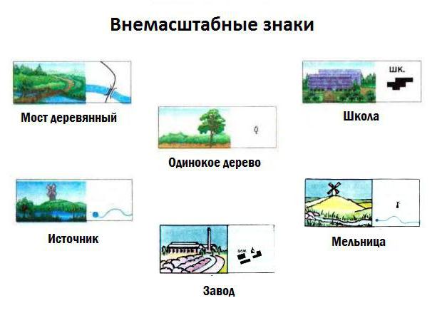
Off-scale signs
If a terrain feature cannot be depicted on the real scale of a plan or map, then non-scale symbols are used. We are talking about too small things, for example, a windmill, a sculptural monument, a rock outcrop, a spring or a well.
The exact location of such an object on the ground is determined by the main point of the symbol. For symmetrical signs this point is located in the center of the figure, for signs with a wide base - in the middle of the base, and for signs based on a right angle - at the apex of such an angle.
It is worth noting that objects expressed on maps by out-of-scale symbols serve as excellent landmarks on the ground. Examples of off-scale cartographic symbols are presented in the figure below:
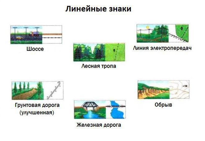
Linear signs
Sometimes the so-called linear cartographic signs are included in a separate group. It is not difficult to guess that they are used to designate linearly extended objects on plans and maps - roads, boundaries of administrative units, railways, fords, etc. An interesting feature of linear designations: their length always corresponds to the scale of the map, but the width is significantly exaggerated.
Examples of linear cartographic symbols are presented in the figure below.
Explanatory signs
Perhaps the most informative is the group of explanatory symbols. With their help, additional characteristics of the depicted terrain objects are indicated. For example, a blue arrow in a river bed indicates the direction of its flow, and the number of transverse strokes on a railroad symbol corresponds to the number of tracks.
As a rule, maps and plans are labeled with the names of cities, towns, villages, mountain peaks, rivers and other geographical features. Explanatory symbols can be numeric or alphabetic. Letter designations are most often given in abbreviated form (for example, a ferry crossing is indicated as the abbreviation “par.”).
Symbols of contour and thematic maps
A contour map is a special type of geographic map intended for educational purposes. It contains only a coordinate grid and some elements of a geographical basis.
The set of symbols for contour maps in geography is not very wide. The very name of these maps is quite eloquent: to compile them, only contour marks of the boundaries of certain objects - countries, regions and regions - are used. Sometimes rivers and large cities are also marked on them (in the form of dots). By and large, a contour map is a “silent” map, which is precisely intended to fill its surface with certain conventional symbols.
Thematic maps are most often found in geography atlases. The symbols of such cards are extremely varied. They can be depicted as a color background, areas or so-called isolines. Diagrams and cartograms are often used. In general, each type of thematic map has its own set of specific symbols.
Definition 1
Cartographic symbols- symbolic graphic symbols that are used to depict various objects and their characteristics on cartographic images (maps and topographic plans).
Sometimes conventional signs are called map legend.
Types of symbols by scale
Depending on the scale, $3$ groups of conventional signs are distinguished:
- scale (area and linear);
- off-scale (point);
- explanatory.
Using area scale symbols, extended objects are displayed on a map scale. On a map, scale marks allow you to determine not only the location of an object, but also its size and outline.
Example 1
Scale symbols are the territory of the state on a map of scale $1:10,000,000$ or a reservoir on a map of scale $1:10,000$.
Linear symbols are used to display objects that are significantly extended in one dimension, such as roads. Only one dimension (in which the object is most extended) is consistent with the scale on such signs, while the other is scale-free. The position of an object is determined by a conventional or explicit centerline.
Out-of-scale point symbols are used on maps to display features whose dimensions are not expressed on the map. The largest cities on the world map are displayed with out-of-scale signs - dots. The actual placement of the object is determined by the main point of the point symbol.
The main point is placed at off-scale signs as follows:
- in the center of the figure for symmetrical signs;
- in the middle of the base for signs with a wide base;
- at the vertex of a right angle, which is the base, if the sign has such an angle;
- in the center of the bottom figure, if the sign is a combination of several figures.
Explanatory signs are intended to characterize local items and their varieties. Explanatory signs may indicate the number of railway tracks and the direction of river flow.
Note 1
On large-scale maps, the symbols of individual objects are indicated separately; on smaller-scale maps, similar objects are grouped and marked with one symbol.
Conventional signs by content
- signs and signatures of settlements;
- signs of individual local facilities;
- signs of individual relief elements;
- transport infrastructure signs;
- signs of hydrographic network objects;
- signs of soil and vegetation cover;
Signs and signatures of settlements
On maps of scale $1:100,000 and larger, all settlements are indicated along with a caption of their names. Moreover, the names of cities are written in upright capital letters, rural settlements - in lowercase letters, urban and holiday villages - in lowercase slanted letters.
Large-scale maps display external contours and layout, highlighting major highways, businesses, prominent knowledge and landmarks.
Example 2
On maps of scale $1:25\000$ and $1:50\000$ the type of building (fireproof or non-fireproof) is shown in color.
The figure below shows signs of settlements used on maps of various eras.
Signs for individual local facilities
Individual local objects, which are landmarks, are depicted on the map mainly with off-scale signs. These can be towers, mines, adits, churches, radio masts, rock outcrops.
Signs of individual relief elements
Relief elements are marked on the map with appropriate symbols.
Note 2
An object of natural origin is depicted with brown lines and marks.
Transport infrastructure signs
Transport infrastructure objects displayed on topographic maps include road and railway networks, structures and bridges.
When plotted on a map, paved roads (freeways, improved highways, improved dirt roads) and unpaved roads are distinguished. All paved roads are shown on the map, indicating the width and material of the pavement.
The color of the road on the map indicates its type. Motorways and highways are painted orange, improved dirt roads are yellow (occasionally orange), unpaved country roads, field, forest and seasonal roads are uncolored.
Signs of hydrographic network objects
The map depicts the following elements of the hydrographic network - the coastal part of the seas, rivers, lakes, canals, streams, wells, ponds and other bodies of water.
Reservoirs are plotted on the map if their area in the image is more than $1 mm^2$. In other cases, a pond is applied only because it is of high importance, for example in arid areas. Next to the objects their name is indicated.
The characteristics of objects of the hydrographic network are indicated next to the signature of the name of the object. In particular, they indicate in the form of a fraction the width (numerator), depth and nature of the soil (denominator), as well as the speed (in m/s) and direction of the flow. Hydraulic structures - ferries, dams, locks - are also indicated along with their characteristics. Rivers and canals are mapped in full. In this case, the type of display is determined by the width of the object and the scale of the map.
Note 4
In particular, at a map scale of more than $1:50,000$, objects with a width of less than $5$ m, at a scale of less than $1:100,000$ - less than $10$ m are represented by a $1$ line, and wider objects - by two lines. Also, $2$ lines indicate channels and ditches with a width of $3$ m or more, and with a smaller width - one line.
On large-scale maps, blue circles indicate wells, with the letter “k” or “art.k” in the case of an artesian well placed next to them. In dry areas, wells and water supply facilities are shown with enlarged signs. Water pipelines on maps are shown by lines with blue dots: solid lines - above-ground, broken lines - underground.
Land cover signs
Often, when displaying land cover on a map, a combination of scale and off-scale symbols is used. Signs denoting forests, shrubs, gardens, swamps, meadows, and character are large-scale, and individual objects, for example, free-standing trees, are non-scale.
Example 3
A swampy meadow is displayed on the map as a combination of symbols of meadow, bushes and swamp in a closed contour.
The contours of areas of terrain occupied by forest, bushes or swamps are drawn with a dotted line, except when the border is a fence, roads or other linear local object.
Areas covered with forest are indicated in green with a symbol indicating the type of forest (coniferous, deciduous or mixed). Areas with forest growth or nurseries are shown in pale green on the map.
Example 4
The picture below on the left shows a coniferous pine forest with an average tree height of $25$ meters and a width of $0.3$ m, and a typical tree trunk spacing of $6$ m. The picture on the right shows a deciduous maple forest with a tree height of $12$ m and a trunk width of $0.2$ m, the distance between which is on average $3$ meters.
Swamps are shown on the map by horizontal shading in blue. In this case, the type of hatching shows the degree of passability: intermittent hatching – passable, solid – difficult and impassable.
Note 5
Swamps with a depth of less than $0.6$ m are considered passable.
The blue vertical shading on the map indicates salt marshes. Just like for swamps, solid shading indicates impassable salt marshes, intermittent shading indicates passable ones.
Symbol colors on topographic maps
The colors used to depict objects on maps are universal for all scales. Black line marks – buildings, structures, local objects, strongholds and borders, brown line marks – relief elements, blue – hydrographic network. Area signs are light blue - water mirrors of hydrographic network objects, green - areas of trees and shrubs, orange - blocks with fire-resistant buildings and highways, yellow - blocks with non-fire-resistant buildings and improved dirt roads.
Note 6
On military and special maps special symbols are applied.
The symbols on a map or plan are a kind of their alphabet, by which they can be read, find out the nature of the area, the presence of certain objects, and evaluate the landscape. As a rule, symbols on a map convey common features with geographical objects that exist in reality. The ability to decipher cartographic symbols is indispensable when making tourist trips, especially to distant and unfamiliar areas.
All objects indicated on the plan can be measured on a map scale to represent their actual size. Thus, the symbols on a topographic map are its “legend”, their decoding for the purpose of further orientation on the terrain. Homogeneous objects are indicated by the same color or stroke.
All outlines of objects located on the map, according to the method of graphic representation, are divided into several types:
- Area
- Linear
- Spot
The first type consists of objects that occupy a large area on a topographic map, which are expressed by areas enclosed within boundaries in accordance with the scale of the map. These are objects such as lakes, forests, swamps, fields.
Line symbols are outlines in the form of lines and can be seen on a map scale along the length of an object. These are rivers, railways or roads, power lines, clearings, streams, etc.
Dotted outlines (out-of-scale) indicate small objects that cannot be expressed on the map scale. These can be either individual cities or trees, wells, pipes and other small individual objects.
Symbols are applied in order to have as complete an idea as possible about the specified area, but this does not mean that absolutely all the smallest details of a real individual area or city have been identified. The plan indicates only those objects that are of great importance for the national economy, the Ministry of Emergency Situations, and military personnel.
Types of symbols on maps
 Conventions used on military maps
 To recognize map signs, you need to be able to decipher them. Conventional symbols are divided into scale, non-scale and explanatory.
- Scale symbols indicate local objects that can be expressed in size on the scale of a topographic map. Their graphic designation appears in the form of a small dotted line or thin line. The area inside the border is filled with symbols that correspond to the presence of real objects in this area. Using scale marks on a map or plan, you can measure the area and dimensions of a real topographical object, as well as its outline.
- Off-scale symbols indicate objects that cannot be displayed on a plan scale, the size of which cannot be judged. These are some separate buildings, wells, towers, pipes, kilometer posts, etc. Out-of-scale symbols do not indicate the dimensions of an object located on the plan, so it is difficult to determine the actual width or length of a pipe, elevator or free-standing tree. The purpose of off-scale symbols is to accurately indicate a specific object, which is always important when orienting yourself while traveling in an unfamiliar area. The exact location of the indicated objects is carried out by the main point of the symbol: this can be the center or lower middle point of the figure, the vertex of a right angle, the lower center of the figure, the axis of the symbol.
- Explanatory signs serve to disclose information about scale and non-scale designations. They give additional characteristics to objects located on a plan or map, for example, indicating the direction of river flow with arrows, designating the forest type with special signs, the load capacity of the bridge, the nature of the road surface, the thickness and height of the trees in the forest.

In addition, topographic plans contain other symbols that serve as additional characteristics for some of the specified objects:
- Signatures
Some signatures are used in full, others in abbreviated form. The names of settlements, rivers and lakes are fully deciphered. Abbreviated labels are used to indicate more detailed characteristics of certain objects.
- Digital legend
They are used to indicate the width and length of rivers, roads and railways, transmission lines, the height of points above sea level, the depth of fords, etc. The standard map scale designation is always the same and depends only on the size of this scale (for example, 1:1000, 1:100, 1:25000, etc.).
In order to make it as easy as possible to navigate a map or plan, symbols are indicated in different colors. More than twenty different shades are used to distinguish even the smallest objects, from intensely colored areas to less vibrant ones. To make the map easy to read, there is a table at the bottom with a breakdown of the color codes. So, usually water bodies are indicated by blue, cyan, turquoise; forest objects in green; terrain – brown; city blocks and small settlements – gray-olive; highways and highways - orange; state borders are purple, neutral area is black. Moreover, neighborhoods with fire-resistant buildings and structures are indicated in orange, and neighborhoods with non-fire-resistant structures and improved dirt roads are indicated in yellow.

The unified system of symbols for maps and site plans is based on the following provisions:
- Each graphic sign always corresponds to a specific type or phenomenon.
- Each sign has its own clear pattern.
- If the map and plan differ in scale, objects will not differ in their designation. The only difference will be in their sizes.
- Drawings of real terrain objects usually indicate an associative connection with it, and therefore reproduce the profile or appearance of these objects.
To establish an associative connection between a sign and an object, there are 10 types of composition formation:


