Filatov military publishing house military topography. Study guide: Military topography. Measurement of directional angles and azimuths
Name: Military topography.
This textbook outlines the course of military topography, the knowledge of which is necessary for every officer.
The first section of the textbook discusses the classification, mathematical basis and geometric essence of topographic maps, their content, methods of reading and measuring them. It also discusses the properties of aerial photographs, the basics of their military interpretation and the rules for their use in solving combat missions.
The second section is devoted to orientation on the ground in various ways, including with the help of navigation equipment.
In the third section, in relation to the practical activities of unit commanders, the use of maps for studying the terrain, assessing its tactical properties, commanding troops and target designation in various types of combat, as well as compiling combat graphic documents, the procedure and methods for conducting reconnaissance of the area are considered.
The appendix contains samples of topographic maps, tables of symbols, different kinds aerial photographs.
The terrain is one of the main and constantly operating factors in the combat situation, which significantly affects the combat activity of the troops. Features of the terrain that affect the organization, conduct of combat and the use of military equipment are called its tactical properties. The main ones include its cross-country ability and orientation conditions, camouflage and protective properties, conditions for observation and firing.
Skillful use of the tactical properties of the terrain contributes to the most effective use of weapons and military equipment, secrecy of maneuver and surprise strikes against the enemy, camouflage from observation and protection of troops from enemy fire. Consequently, when performing combat missions, each serviceman must be able to quickly and correctly study the terrain and evaluate its tactical properties.
Content
Introduction
§ 1. Subject, content, tasks and method of military topography
§ 2 Place and role of military topography in the system of combat training of troops
SECTION ONE
TOPOGRAPHIC MAPS AND AERIAL IMAGES, THEIR USE IN THE TROOPS
Chapter 1. Classification, purpose and geometric essence of maps
§ 3. Main types of cards
1. Features of the cartographic image
2. General geographic and special maps
3. Classification and purpose of topographic maps
§ 4. Mathematical basis for the construction of maps
1.Geometric essence of the cartographic image
2. Distortions in map projections
3. Reference geodetic networks
§ 5. Projections of Soviet topographic maps
1. Projection of maps of scales 1:25,000-1:500,000
2. Map projection at a scale of 1:1000000
§ b. Layout and nomenclature of topographic maps
1. Map layout system
2. Nomenclature of map sheets
3. Selection and issuance of the nomenclature of map sheets for the required area.
Chapter 2 Map Measurements
§ 7. Measurement of distances and areas
1. Map scale
2.Measuring lines on the map
3 Accuracy of measuring distances on the map
4.Corrections in distances for slope and tortuosity of lines
5. The simplest ways to measure areas on the map
§ 8. Determination of the coordinates of terrain points and objects (targets) on the map
1. Coordinate systems used in topography
2. Determination of geographical coordinates
3. Definition of rectangular coordinates
§ 9. Measurement on the map of directional angles and azimuths
1. Azimuths and directional angles
2.Measurement and construction of directional angles on the map
3. Transition from directional angle to magnetic azimuth and vice versa
Chapter 3 Reading Topographic Maps
§ 10. System symbols on the maps
1.Completeness and detail of the image of the area
2.Principles of construction and application of symbols on maps
3 Pitchfork symbols
4.Color design (coloring) of cards
5. Explanatory signatures and digital designations
6.General rules card reading
§eleven. The image of the relief on the maps
1. Types and elementary landforms
2. The essence of the image of the relief by contour lines
3. Types of contour lines
4 Depiction by contour lines of elementary landforms
5. Features of the image by contour lines of flat and mountainous terrain
6. Conventional signs of relief elements that are not expressed by horizontal lines
Features of the relief image on maps of scales 1:500,000 and 1:1000,000
§ 12. Studying the relief on the map
1.Study of the structure and elementary landforms
2.Definition absolute heights and mutual elevations of terrain points
3. Determination of ascents and descents
4. Determination of the shape and steepness of the slopes
§ 13. Image on maps of water bodies
1. Coastal strips and coasts of the seas, large lakes and rivers
2. Lakes, reservoirs and other bodies of water
3. Rivers, canals and other objects of river systems
4. Wells and other sources of water
5. Additional data on water bodies contained in certificates of the area on a map at a scale of 1: 200,000
§ 14. Image of vegetation cover and soil
1. The main elements of the vegetation cover
2. Soil and ground cover
§ 15. Image settlements, industrial enterprises and social and cultural facilities
1. Settlements
2.Industrial and agricultural production enterprises and facilities
3. Communication facilities, power lines, pipelines, airfields and social and cultural facilities
§ 16. Image of the road network
1.Railways
2. Highways and dirt roads
§ 17. Borders and geodetic points
1. Borders and fences
2. Geodetic points and individual local objects - landmarks
Chapter 4
§ 18. Types and properties of aerial photographs
1. Aerial photographs as reconnaissance and measuring documents
2. Types of aerial photographs
3 The use of aerial photographs in the troops
4.Geometric essence of aerial photographs
5. The concept of distortion in aerial photographs
6. Figurative properties of aerial photographs
7. The concept of photographic documents
§ 19. Preparation of aerial photographs for work
1. Linking aerial photographs to the map
2. Determining the scale of a planned aerial photograph
3. Drawing on aerial photographs the direction of the magnetic meridian
4. The concept of preparation for work and the use of promising aerial photographs
§ 20. Measurements from aerial photographs
1.Aerial photography accessories
2. Stereoscopic (volumetric) viewing of aerial photographs
3. Determination of distances and sizes of objects from aerial photographs
4. Transferring objects from an aerial image to a map
5. Determination of rectangular coordinates from aerial photographs
§ 21. Interpretation of aerial photographs
1. Unmasking (decoding) signs
2. Methods for deciphering aerial photographs
3. Reliability and completeness of interpretation of aerial photographs
4.Deciphering the objects of the area
5. The concept of deciphering tactical objects
SECTION TWO
TERRAIN ORIENTATION
Chapter 5
§ 22. Essence of orientation
§ 23. Determination of distances when orienting on the ground and target designation
1. Eye gauge
2. Determination of distances by measured angular dimensions of objects
3. Determination of distances by speedometer
4. Measurement steps
5. Determination of distances by the time of movement
§ 24. Devices and methods for determining directions and measuring angles on the ground
1. Magnetic compass and its application
2. Gyro semi-compass and its use
3. Field measurement of horizontal angles
4. Determining and maintaining the direction of movement along the heavenly bodies
§ 25. Techniques for orienting on a map (aerial photograph)
1. Map orientation
2. Determination on the map (aerial image) of your location
3. Comparison of the map with the terrain
§ 26. Orientation on the map while moving along a given route
1. Preparation for orientation
2. Orientation on the way
3.Features of orientation when moving in various conditions
4. Restoration of lost orientation
§ 27. Movement in azimuths
1.Preparation of data for movement in azimuths
2. Movement in azimuths
3. Obstacle avoidance
4. Finding your way back
5. Accuracy of movement in azimuths
§ 2S. Responsibilities of unit commanders to ensure orientation and target designation on the battlefield
1. Selection and use of landmarks
2 Orientation on the ground commanders of subordinate and supporting units
3. Measures that provide orientation during operations at night and on terrain poor in landmarks
Chapter 6
§ 29. The principle of operation and the main instruments of navigation equipment
1. The principle of determining the current coordinates of a moving machine
2.Basic instruments of navigational equipment
3. Machine location accuracy
§ 30. Preparation for orientation
1.Inspection and start-up of the equipment
2. Balancing the gyroscope of the course indicator
3.Checking the sighting device of the machine
4. Studying the route of movement and preparing the map
5. Preparation of initial data
6. Setting coordinates and directional angle
§ 31. Orientation on the ground with the help of a coordinator
§ 32. Features of preparation for work and operation of the course plotter
R SECTION THREE
USE OF CHARTS AND AERIAL IMAGES BY UNIT COMMANDERS
Chapter 7
§ 33. Preparing the card for work
1. Familiarization with the map
2. Card bonding
3.Folding the card
4.Card lift
§ 34. Basic rules for maintaining and using a work card
1.Basic rules for applying the situation to the work map
2. Using the map in reports, setting the task of compiling combat documents
§ 35
1. Determination of landmarks and goals and drawing them on the map
2. Mapping the elements of your battle order
3. Determination on the ground and mapping of fields of invisibility
§ 36. Target designation on the map and aerial photographs
1. Target designation in rectangular coordinates
2. Target designation by squares of a kilometer grid
3. Target designation from a conditional line
4. Target designation from the nearest landmarks and contours shown on the map
5. Target designation in azimuth and range to the target
6. Target designation from aerial photographs
Chapter 8
§ 37. General rules for studying and assessing the terrain
§ 38 Definition general terrain
§ 39. Study of the conditions of observation and camouflage properties of the terrain
1. Determination on the map of mutual visibility of points
2. Definition and mapping of fields of invisibility
3. Construction on the map of terrain profiles
4. Influence of the curvature of the Earth and atmospheric refraction on the observation range
§ 40 Study of terrain conditions
1. Study of the road network
2.Study of terrain off-road
3. Conclusions on the impact of terrain on the performance of a combat mission
§ 41. Study of the protective properties of the terrain
1. Study of the protective properties of the relief
2. Study of the protective properties of the forest and the nature of soils and soils
3. Conclusions on the influence of the protective properties of the terrain on the performance of a combat mission
§ 42. Study of the conditions of firing
1.Determination of the depth of shelter
2. Determining the angle of cover
3. Determining the elevation angle of the target
§ 43. The concept of predicting changes in terrain in the area of a nuclear explosion
1. Determination of the degree of destruction of terrain objects and the heat of fires
2. Registration on the map of forecasting results
§ 44. An example of the study and assessment of the terrain on the map by the commander
motorized rifle platoon assigned to the head outpost
§ 45. An example of studying and evaluating "the terrain by the commander of a motorized rifle company during an offensive from direct contact with the enemy
Chapter 9
§ 46. Methods of reconnaissance of the area
1.Observation
2. Inspection of the area by patrols
3.Examination
§ 47. Route reconnaissance
§ 46. Reconnaissance of individual terrain objects
1.Forest reconnaissance
2. Swamp reconnaissance
3.Exploration of the river
4. The concept of reconnaissance of terrain changes in the focus of a nuclear explosion
§ 49. Graphic documents with intelligence information
1. Graphic accounting of intelligence information in units
2. Types of combat graphic documents
3. Rules for drawing combat graphic documents
4. Techniques for compiling terrain maps on a map or aerial photographs
Applications:
1. List of abbreviated signatures used on topographic maps
II. Some indicative data on the passability of the terrain
III. Making a layout on the ground
IV. Answers to examples and tasks
Alphabetical index
V. Samples of topographic maps of the USSR
VI. The image on the maps of some varieties of flat, hilly and mountainous terrain
VII. Tables of symbols for topographic maps
VIII. Clippings from maps at scales 1:50,000 and 1:100,000
IX. Samples of aerial photographs for interpretation
Topic #2
Fundamentals of military topographyLesson #1
Topographic maps and their reading Study questions
№
p/p
1.
2.
3.
4.
QUESTIONS
The essence of the topographic image of the area.
Mathematical and geodetic basis of maps.
Layout and nomenclature of topographic maps.
Definition of the nomenclature of adjacent sheets.
Classification topographic elements
terrain.
The study and evaluation of terrain elements on the map.
Determination of their quantitative and qualitative
characteristics.
learning goals
Explain to students the essence of the imageterrain on topographic maps and
classification of topographic elements
terrain.
Understand the order of division and nomenclature
topographic maps, definition
nomenclature of adjacent sheets.
Literature
"Military topography".
M., Military publishing house, 2010
pp. 9-26, 35-38, 47-53, 60-64, 150-161.
For additional study: pp. 26-34, 38-47,
53-59.
1. The essence of the topographic image of the area. Mathematical and geodetic basis of maps.
Military topography(from the Greek topos - area, graphy - I write)
- a special military discipline on the methods and
means of studying and assessing the terrain,
orientation on it and the production of field
measurements to ensure combat
activities of troops (forces), on the rules for conducting
work cards of commanders and development
graphic combat documents.
The geometric essence of the image of the earth's surface on the map.
Geographic location of pointsearth's surface determined by their
coordinates. That's why
mathematical construction problem
cartographic image
is to design for
plane (map) spherical
Earth's surface under strict
observance of an unambiguous
correspondence between coordinates
points on the earth's surface and
their image coordinates on
map. Such a design requires
knowledge of the shape and size of the earth.
The dimensions of the earth's ellipsoid at different times were determined by many scientists based on the materials of degree measurements.
Author of the definitionCountry where
published
definitions
Year
Big
semi-axis definitions
Bessel
Germany
1841
6 377 397
1:299,2
Clark
England
1880
6 378 249
1:293,5
Hayford
USA
1910
6 378 388
1:297,0
Krasovsky
USSR
1940
6 378 245
1:298,3
Compression
Horizontal spacing
When depicting the physical surface of the Earth on a map (plane), itsfirst project with plumb lines on a level surface, and then
already according to certain rules, this image is deployed on
plane.
On fig. horizontal spacing(plan image) points, straight line,
broken and curved lines
The image in terms of points and lines of the earth's surface is called their
horizontal spacing or horizontal projection.
Map projections
The set of elements shown on the map andterrain objects and reported about them
information is called
map content.
The essential features of the card are:
visibility,
measurability and
high information content. Visibility of the map the possibility of visual
perception of spatial shapes, sizes and
placement of depicted objects.
Measurability is an important property of a map, closely
related to the mathematical basis, provides
possibility with the accuracy allowed by the scale
maps, determine the coordinates, sizes and
placement of terrain objects, use maps
in the development and implementation of various events
national economic and defense significance,
solving problems of a scientific and technical nature,
map measurability is characterized by the degree
matching the location of points on their map
location on the mapped surface.
The information content of a map is its ability
contain information about the depicted objects or
phenomena. Displaying the surface of an ellipsoid or sphere on a plane
called a map projection. Exist
different kinds map projections. To each of them
correspond to a certain cartographic grid and inherent
her distortion (area, angles and lengths of lines).
Map projections are classified:
- by the nature of the distortions,
- view of the image of meridians and parallels
(geographic grid),
- by orientation relative to the axis of rotation of the globe and
some other signs.
According to the nature of the distortions, the following are distinguished:
map projections:
- equiangular - preserving the equality of angles between
directions on the map and in kind;
On fig. world map in
conformal projection - equal area - preserving the proportionality of areas
on the map to the corresponding areas on the earth's ellipsoid.
Mutual perpendicularity of meridians and parallels on such
the map is saved only along the middle meridian;
On fig. world map in
equal area projection
- equidistant - maintaining the constancy of scale
in any direction;
- arbitrary - not preserving their equality of angles, nor
proportionality of areas, nor constancy of scale. Meaning
application of arbitrary projections is more
uniform distribution of distortion on the map and convenience
solving some practical problems.
The content of topographic maps must be: complete, reliable, up-to-date and accurate.
The completeness of the content of the maps means that on themall typical features should be depicted and
characteristic topographical elements reflecting in
first of all in
according to the scale of the map and its purpose.
Reliability (correct information,
depicted on the map at a certain time) and
modernity (correspondence to the current state
displayed object) maps mean that the content
cards must be in full accordance with
locality at the time of using the map.
Map accuracy (degrees of correspondence
locations of points on the map their location in
reality) means that depicted on it
topographical elements of the terrain must preserve
accuracy of its location, geometric
similarity and size in accordance with the scale of the map and
her appointment.
The main scales of topographic maps are: 1:25,000, 1:50,000, 1:100,000, 1:200,000, 1:500,000 and 1:1,000,000.
Map scale 1:25 000 (in 1cm - 250m); 1:50 000 (in 1cm - 500m) andmap scale 1:I00 000 (in 1cm - 1km) are intended for study
terrain and assessment of its tactical properties when planning a battle,
organization of interaction and command and control of troops, orientation to
terrain and target designation, topographic and geodetic binding of elements of combat
orders of troops, determining the coordinates of objects (targets) of the enemy, and
as well as a 1:25000 scale map are used in the design
military engineering facilities and the implementation of measures to
engineering equipment of the area.
Map scale 1:200,000 (in 1 cm - 2 km) is intended for studying and
assessment of the terrain when planning the combat operations of troops and
measures for their provision, command and control.
Map scale 1:500 000 (in 1 cm - 5 km) is intended for studying and
assessment of the general nature of the terrain in the preparation and conduct of operations.
It is used in the organization of interaction and management
troops, for orientation during the movement of troops (in flight) and
target designation, as well as for applying a general combat situation.
Scale map I:I 000 000 (in 1cm - 10km) is intended for general
assessment of the terrain and study of the natural conditions of areas, theater of operations,
command and control of troops and other tasks. City plans
created in the cities
major railway junctions, naval bases and other important population centers
points to their surroundings. They are
intended for detailed study
cities and approaches to them,
orientation, performing precise
measurements and calculations in the organization and
conducting the battle.
Flight (route-flight) cards
are included in the mandatory set of pilot's equipment and
navigator and are essential for navigation purposes. On the
flight charts, the bulk of the work is done when
preparation and directly during the flight itself. At
preparation for the flight on the maps is laid and marked
route, landmarks are selected and studied and
turning points to control the path.
Flight and route charts are
essential for the purposes
navigation: reference visual
and radar
disguise, and
fulfillment
necessary measurements and
graphic constructions at
flight control. Aeronautical and topographic maps
Onboard maps
intended for navigation in cases where
the aircraft is forced to leave the flight map, and
such for processing navigational measurements obtained from
using radio engineering and astronomical means
navigation.
Target Area Maps
- this is large scale maps from 1:25000 to 1:200000
in the Gaussian projection. These cards are used to calculate and
determining the coordinates of given objects, for
orientation, target designation and detection of small
objects on the ground. Aeronautical and topographic charts
Special cards
are used in solving problems of automated
the withdrawal of aircraft to ground targets, their target designation and
flight control and are designed to address
navigation tasks based on measurement data obtained from
using radio equipment. These include cards
different scales and projections on which lines are applied
provisions.
Please note that special and on-board cards may
fit together.
Reference cards
designed for various references needed
when planning and preparing for flights. These include
maps of major airfield hubs, survey navigation
maps, maps of magnetic declinations, time zones,
climatic and meteorological, star charts,
advisory and others.
2. Layout and nomenclature of topographic maps. Definition of the nomenclature of adjacent sheets.
The system of dividing the map into separate sheetsis called map layout, and the system
designations (numbering) of sheets - their
nomenclature. The basis for the designation of sheets of topographic maps of any
scale, the nomenclature of sheets of a millionth map is laid down.
Sheet nomenclature
scale maps
1:1,000,000 is made up of
row indications (letters) and
columns (numbers), in
crossing which he
located, for example,
sheet from the city of Smolensk has
nomenclature
N-36 Nomenclature of map sheets at scales 1:100,000 - 1:500,000
is composed of the nomenclature of the corresponding sheet of a millionth
cards with the addition to it of a number (numbers) or a letter indicating
the location of this sheet on it.
- sheets of scale 1:500,000 (4 sheets) are designated in Russian
capital letters A, B, C, D. Therefore, if the nomenclature
sheet of a millionth map will be, for example, N-36, then the scale sheet
1:500,000 from the city of Polensk has the nomenclature N-36-A;
- sheets of scale 1:200,000 (36 sheets) are indicated
Roman numerals from I to XXXVI. So the nomenclature
sheet from the city of Polensk will be N-36-IX;
- sheets of scale 1:100,000 are numbered from 1 to
144. For example, a sheet from the city of Polensk has the nomenclature N-36-41.
A map sheet at a scale of 1:100,000 corresponds to 4 scale sheets
1:50 000, denoted by Russian capital letters "A, B, C, G",
1:50,000 scale sheet - 4 map sheets 1:25,000, which
are indicated by lowercase letters of the Russian alphabet "a, b, c, d".
For example, N-36-41-B denotes a 1:50,000 scale sheet, and
N-36-41-В-а - sheet of scale 1:25,000. Rules and procedure for the formation of topographic
maps of all scales
3. Classification of topographic elements of the area.
Reliefis a set of irregularities in the physical
the surface of the earth. The combination of uniform forms,
similar in appearance, structure and size and
regularly repeating on a certain
territories, form various types and
landform types.
There are two main types of relief: mountainous
relief and flat relief.
- In turn, the mountainous relief is divided into:
1. Low mountains - 500-1000 m above sea level.
2. Medium-altitude mountains - 1000-2000 m above the level
seas.
3. High mountains - over 2000 m above sea level. The flat relief is subdivided into
flat and hilly terrain.
The flat terrain is characterized
absolute heights up to 300 m above the level
sea and relative elevations up to 25
m.
The hilly area is characterized
undulating nature of the earth's surface
absolute heights up to 500 m. And
relative elevations of 25-200 m.
AT
turn hilly country into
depending on the nature of the elevations and
depressions crossed by hollows can be:
- slightly hilly (slightly hilly);
- sharply hilly (very hilly);
- valley-beam;
- ravine-beam. Depending on the soil and vegetation cover
the area can be:
- desert (sandy, rocky, clayey);
- steppe;
- forest (wooded);
- swampy (peat bogs and wetlands);
- wooded-swampy.
The terrain of the northern regions belongs to a special type. Types of vegetation in the area:
tree and shrub plantings;
meadow tall grass and steppe grassy and
semi-shrub;
reed and reed thickets;
moss and lichen vegetation;
artificial plantations.
Tactical properties of the terrain
Terrain properties influencingon the organization and conduct of combat, the use
weapons and military equipment, commonly called
tactical properties.
Tactical properties of the terrain
1.Terrain passability
is a property of the terrain that facilitates or restricts
troop movement.
Permeability determines, first of all, the presence of a road network,
the nature of the relief, soil and vegetation cover, the presence
and the nature of rivers and lakes, seasons and weather conditions;
type of shape and steepness of slopes. Serious obstacles
are swamps.
According to the patency of the swamps are divided into:
passable, impassable and
impassable.
Depends on the specific climatic conditions of a particular area
(in winter, impassable swamps in summer can serve as convenient
ways for the movement and actions of troops).
________________________________________________________________________________________________
The passability of forests depends on the availability of roads and clearings, and
also on the density, thickness of trees and the nature of the relief.
According to the degree of indentation of the terrain by obstacles (ravines,
rivers, lakes, swamps, etc.), restricting freedom
movement on it, the area is divided into:
slightly crossed, medium crossed and
strongly crossed. Tactical properties of the terrain
The terrain is considered to be slightly rugged, about 10% of the area
The medium terrain is characterized by the fact that
which is occupied by obstacles. If there are no obstacles or if they are
less than 10%, the terrain is classified as uncrossed.
obstacles that impede movement occupy 10-30% of its area.
If more than 30% of the area is occupied by such obstacles, the area is classified as
strongly crossed. (creates favorable conditions for secretive
approach to the front line of the enemy, but makes it difficult to move their own
divisions.
Tactical properties of the terrain
are the properties of the terrain that weaken the actions
damaging factors of nuclear and conventional weapons and
facilitating the organization of the defense of troops. They are defined
mainly by the nature of the relief and vegetation
cover.
Good shelters can serve as caves, mines,
galleries, etc. Small units as cover
can use relief details (pits, gullies, ditches,
mounds, embankments, etc.).
Large tracts of forest weaken the impact
waves of a nuclear explosion. Dense deciduous and coniferous forests
well protect against light radiation and reduce the level
penetrating radiation.
Tactical properties of the terrain
2. Protective properties of the terrainThe best protective properties against nuclear weapons
has a medium-aged dense forest, as well as a high
deciduous shrub. In a young forest and shrubs, it is excluded
defeat of troops by falling trees.
Terrain with good protective properties has
deep hollows, ravines, gullies with steep slopes and
hilly terrain.
In the mountains, the effect of the shock wave may be intensified or
weaken depending on the position of the epicenter of the nuclear
explosion in relation to the direction of the ridges and valleys. Wherein
its damaging effect can be significantly enhanced
flying fragments of rocks, as well as landslides,
rockfalls and snow avalanches.
The weakest protective properties are
desert and steppe, open and flat
the nature of which contributes to the unhindered
propagation of a shock wave, penetrating radiation and
radioactive contamination of air and terrain. Tactical properties of the terrain
Camouflage terrain properties and conditions
observations
3.
- these are terrain properties that contribute to covert from the enemy
actions of the troops and obtaining the necessary information about him by observation. They are
determined by the degree of visibility of the surrounding area, range
review and depend on the nature of the relief, vegetation cover, inhabited
points and other objects that obstruct the view of the area.
Depending on this, the area is divided into:
open, semi-closed and closed.
The open area is devoid of natural masks,
formed by landforms and local objects, or they occupy
no more than 10% of its area. This area allows you to view
command heights almost its entire area, which creates good conditions for
observation of the battlefield, however, makes it difficult to disguise and hide from
surveillance and firing.
Terrain with hilly or flat terrain (rarely mountainous),
on which natural masks occupy about 20% of the area, refers to
to half closed. The presence of natural masks well provides
camouflage of units when located on the spot. However, about
50% of the area of such terrain is visible from command heights.
Tactical properties of the terrain
closed areaallows you to view less than 25%
its area. This creates good conditions for camouflage and shelter from
enemy fire, but makes it difficult to control the unit in battle,
battlefield orientation and interaction.
Tactical properties of the terrain
Properties that affect conditionsorienteering
4.
- these are the properties of the area that contribute to the definition of its
location and desired direction of movement relative to the sides
horizon, surrounding terrain objects, as well as relatively
location of own troops and enemy troops. They are defined
the presence of characteristic relief elements and local
objects that stand out distinctly from other objects in their
appearance or position and convenient to use as
landmarks.
The assessment of orientation conditions is especially
essential in the actions of units in the mountains,
desert, steppe, wooded and swampy areas, where
few guidelines. In such cases, there are
additional orientation activities
units on the ground, the use of navigation
equipment, setting up light landmarks.
4. Study and evaluation of terrain elements on the map. Determination of their quantitative and qualitative characteristics.
A detailed study of the area is guided by the following generalrules:
1. The terrain is studied and evaluated in relation to specific
unit actions, for example, in order to organize a fire system and
surveillance, protection against weapons of mass destruction, determination
hidden approaches to enemy targets, etc.
2. The area is studied continuously, on the spot and on the move, day and night,
taking into account the influence of seasonal phenomena and weather, as well as changes that
occurred or may occur on the ground as a result of combat
actions, especially in nuclear explosions. As a result of studying
terrain, the commander must always have the most complete
and reliable information about it.
3. The area is studied and evaluated not only “for themselves”, but also “for
adversary." This allows you to establish the influence of terrain conditions on its
probable actions, on the location of his battle formations,
defensive structures and barriers, as well as to identify weak
places at the location of your unit in order to timely
take the necessary measures. It is recommended to study the area in
this sequence:
- on the offensive - first in his
location and then location
adversary,
- in defense - on the contrary. The list of questions to be studied, and
the details of their study are determined in
in accordance with the nature of the received combat
tasks. Area or type of combat activity
Required to study
In the area of concentration
Masking conditions and protective properties of the terrain; patency within the area and natural
obstacles; condition of roads and column tracks for advancement to the initial area, detour routes
obstacles; landmarks along the routes; deployment lines; terrain folds and
natural masks for covert movement.
In the starting area for the offensive
Conditions for observation, camouflage and firing; protective properties of the area; the nature of the approaches to
the location of the enemy and natural obstacles; command heights in position
enemy and visibility from them; patency of the terrain in the depth of the enemy’s position,
character shelter and natural masks.
When coming at night
In addition to the above, landmarks that are clearly visible at night are studied; silhouettes of elevated locals
objects, individual vertices, etc.
When attacking with overcoming the water
barriers
The general outline of the barrier in the forcing section; width, depth and speed of the current; Availability
fords, crossings and islands; the nature of the banks and slopes of the valley: the nature of the bottom soil, banks and
floodplains: approaches to a water barrier; conditions for observation, firing and camouflage; availability and
the nature of the shelter; availability of materials necessary for the equipment of crossings.
In the area of defense
Command heights in the location of the enemy and visibility from them of the defense area; folds
terrain and natural masks that allow the enemy to covertly move and
accumulating for attacks: the road network at the location of the enemy; patency and
the nature of the natural obstacles in front of the leading edge; the presence of hidden approaches with
side of the enemy; observation conditions. firing and camouflage in its location:
protective properties of the area; hidden routes of movement in the defense area.
When fighting in the mountains
The main ways and directions of possible movement: roads, trails, passes, as well as command
the heights from which they are viewed; nature of river valleys and mountain rivers: conditions for conducting
fire; shelters: places of possible mountain collapses, blockages and snow avalanches during nuclear explosions.
When fighting in the forest
The nature of the forest - density, height, thickness of trees, crown density, layering; terms
orientation, observation and firing; direction, length and width of clearings;
availability and condition of forest roads; the presence of ravines, beams and heights, their characteristics; Availability
swamps, their patency; the nature of the terrain when leaving the forest.
When fighting in a populated area
paragraph
General layout; location of areas, direction and width of the main highways;
the location of solid stone buildings, bridges, telephone and telegraph stations,
radio stations, overpasses, metro stations and railway stations: underground structures
and ways of possible movement underground; rivers, canals and other bodies of water: location
water sources.
In the strip (direction) of intelligence
Passability on roads and off roads; conditions of camouflage and surveillance; hidden routes.
natural obstacles and ways to bypass them: landmarks; possible places of the device, character
area of a possible meeting with the enemy.
The determination of distances by the angular dimensions of objects is based on the relationship between angular and linear quantities. This dependency is
Determination of distances by angular dimensionsobjects is based on the relationship between angular and linear
quantities. This dependence is that the length of 1/6000 of any
a circle is equal to ~ 1/1000 of the length of its radius. Therefore, the division of the goniometer
usually called a thousandth (0-01), equal to 3.6 gr.
Thus, to determine the distance to an object, the dimensions
which are known, you need to find out how many thousandths of an arc of a circle
occupies the observed object.
2pR/6000=6.28R/6000=0.001R
0-01=(360g*60min)/6000=3.6g
where: D - distance to the object in meters; t is the angular magnitude of the object in thousandths; h - height (width) of the object in meters. For example, telegraph
1000hD
t
where: D - distance to the object in meters;
t is the angular magnitude of the object in thousandths;
h - height (width) of the object in meters.
For example, a telegraph pole 6 meters high is closed
10 mm on the ruler. The angular value of an improvised object can be
also determined using a millimeter ruler. For this
the width (thickness) of the object in millimeters must be multiplied
by two thousandths, since one millimeter of the ruler with its
at a distance of 50 cm from the eye corresponds to the thousandth formula
angular value in two thousandths. Measuring angles in thousandths can
produced:
goniometric circle compass;
binocular and periscope reticle;
artillery circle (on the map);
the whole sight;
sniper side adjustment mechanism
sight;
observation and aiming devices;
officer and other line with
millimeter divisions;
handy items. Binoculars - a device used to monitor the battlefield.
Consists of two spotting scopes interconnected by a common
axis.
Each spotting scope includes an eyepiece, an objective and two
prisms. In the right pipe, in addition, there is a goniometric grid, with
which is used to measure the angular value
subject.
In the field of view of the binoculars, there are two mutually perpendicular
goniometric scales for measuring horizontal and vertical
corners. Divisions are applied to them: large, equal to 10 thousandths
(0-10), and small, equal to five thousandths (0-05).
To measure the angular magnitude of any object (object), it is necessary to point at
him binoculars, count the divisions of the scale,
covering the observed object, and
convert the received reading to thousandths.
Sizes of the most common items.
Dimensions in metersItems
height
width
length
5-7
-
-
-
-
50-60
7-8
-
-
18-20
-
-
passenger two-axle
4,3
3,2
13,0
passenger four-axle
4,3
3,2
20,0
commodity two-axle
3,5
2,7
6,5-7,0
commercial four-axle
4,0
2,7
13,0
Four-axle railway tank car
3,0
2,75
9,0
Railway platform four-axle
1,6
2,75
13,0
cargo
2,0-2,15
2,0-3,5
5,0-6,0
passenger car
1,5-1,8
1,5
4,0-4,5
armored personnel carrier
2,0
2,0
5,0-6,0
implement with tractor
-
-
10,0
heavy (no guns)
2,5-3,0
3,0-3,5
7,0-8,0
medium
2,5-3,0
3,0
6,0-7,0
lungs
2,0-2,5
2,5
5,0-5,5
easel machine gun
0,5
0,75
1,5
Sidecar motorcyclist
1,5
1,2
2,0
Medium height man
1,65
-
-
Communication line wooden pole
Distance between poles of the communication line
Peasant house with a roof
middle age forest
Railway cars:
Cars:
Tanks:
Homework
pp. 59 No. 4, 6, 8, 9, excellent No. 5;p. 172 No. 7, 8, 9, 10, excellent
№24.
Prepare for a tactical flight
Outline.
Military topography
Military topography is a science that makes it possible to develop methods and means for obtaining information about various terrain in the interests of combat activities.
The purpose of topography
When using a completely powerful weapon and radio equipment, it is required to make accurate topographic and geodetic measurements and calculations according to their approximate direction of further actions, as well as determining the distance of their target. As a rule, such guns do not have a small distance to hit the target, therefore, it requires the utmost accuracy of measurement. But success in combat may require the most maximal, but precise solutions to the use of measuring technology. But it is also important that each member of the squad has a good eye and can quickly orient themselves and find a way to measure the distance to the target and other objects.
Simple Measurement Techniques
Simple linear and angular measurements are in demand for reconnaissance and terrain orientation, as well as for initial shooting data. The eye gauge is the most in a simple way for measurement, it is available to every military serviceman and is applicable in any conditions. Field binoculars are also used for measurements; in the field of view of the binoculars there are two goniometric scales used to measure vertical and horizontal angles. If binoculars are not present, then you can use the usual ruler, but you need to have certain skills. Instead of a ruler, you can use improvised items such as:
palm
finger
Matchbox
pencil
Also, an indispensable assistant is a compass, which helps to navigate in the desired direction of the path. A map that has many meanings and has several varieties becomes an indispensable assistant.
reference Information
Azimuths and directional angle. Magnetic declination, meridian convergence and direction correction Choice of landmarks. Target designation from the landmark, in azimuth and range to the target, pointing the weapon at the target Maintaining the specified (planned) direction of movement and distance. obstacle avoidance Compliance with the standard: "Movement in azimuths on foot" Compliance with the standard: "Orientation on the map" Compliance with military topography standards: 1.3, 5-10 Compliance with the standards: "Determining the direction (azimuth on the ground)" and "Measuring distances (angles) on the ground using binoculars (rulers with millimeter divisions)" Fulfillment of standards: "Reading the map" Measurement and construction of directional angles on the map. Transition from directional angle to magnetic azimuth and vice versa Measuring distances on the map. Study of the area. Reading the map along the route Measurement of angles and distances on the ground Image and reading of local objects on maps: hydrography, vegetation cover and soil, settlements, industrial enterprises and socio-cultural facilities, road network and individual local landmarks The study of the tactical properties of the terrain: observation conditions and camouflage properties of the terrain (determining the mutual visibility of points), patency conditions, protective properties of the terrain Linear and angular units Map scales The terrain as an element of the operational-combat situation. Determination on the map of the general nature of the terrain Obstacle avoidance. Finding your way back Familiarization with the map (evaluation of the map), clarification of the scale, height of the section, year of survey and reconnaissance, year of publication, correction of direction, digitization of the coordinate grid Determination of azimuths to local objects Determination of geographical coordinates and mapping of objects by known coordinates Determination on the map of absolute heights and relative elevations of terrain points, ascents and descents, steepness of slopes Determination of directions to the sides of the horizon by compass, celestial bodies, signs of local objects Determining the position of objects (points) in systems of polar and bipolar coordinates, mapping objects by direction and distance, by two angles or by two distances Determination of rectangular coordinates of points. Drawing points on the map by their coordinates Determining the sides of the horizon, magnetic azimuths, horizontal angles and compass heading Determining the nature of local objects from images on maps Orientation on the ground without a map. Determining your location in relation to surrounding local objects. Maintaining the direction of movement along the celestial bodies, local objects, given azimuths Orientation on the ground without a map. Essence of Orientation Orientation on the terrain in azimuths. Magnetic azimuth. Determination of azimuths to local objects Orientation on the ground according to the map (scheme): methods of orienting the map (scheme), the procedure for identifying landmarks, determining one's location, comparing the map (scheme) with the terrain Orientation on the ground on the map of the commanders of subordinate units and other persons Orientation on the map. Orientation of the map in directions to the sides of the horizon, to landmarks, along a linear landmark. Landmark recognition Orientation using a gyro semi-compass. Orientation map in the car. Exit to the destination Basic rules for maintaining a work card. Card lifting. Symbols and abbreviations used when maintaining a work card and compiling other graphic documents. The main elements of the content of the map. Scale, off-scale and explanatory symbols. Making cards. General rules for reading topographic maps Features of orientation on the terrain in conditions of limited visibility Preparing data for movement in azimuth The concept of service graphic documents, their purpose and content The sequence and main issues of studying and assessing the terrain in planning and conducting operational combat operations and performing special tasks Rectangular coordinate grid on topographic maps and its digitization. Additional grid at the junction of coordinate zones
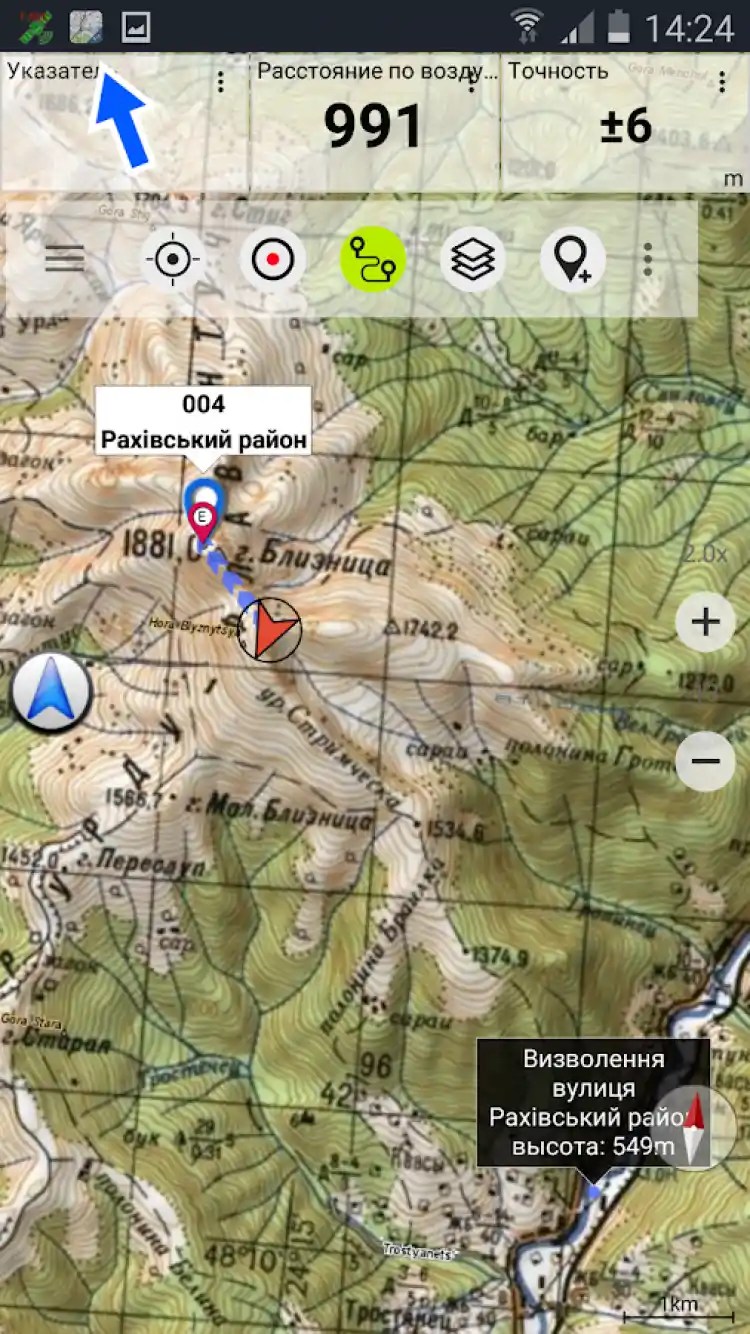
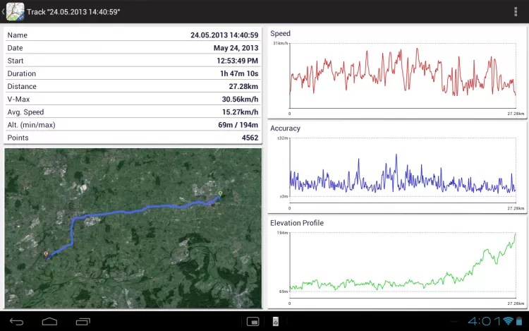
A program that includes a set of high quality topographic maps, some of which were created by the Russian General Staff.
Application Soviet military maps includes topographic maps of the world providing continuous coverage around the world at a scale of 100K-500K, road maps, terrain and satellite images from Google Maps, as well as a number of open street maps.
Nice feature of the app Soviet military maps for Android is the presence of a large number of roads that are not plotted on other maps. It is also worth noting that soviet maps have lost their relevance for developed countries, since they were created in the 80s and it is desirable to use them only for African and Asian countries. In other cases, it is recommended to use google maps and OSM layers.
Download the app Soviet military maps: one of best apps for off-road navigation, on your Android.
Security guarantee
On the FreeSoft website you can download the official version of the Soviet military maps Free without torrents via a direct link from your own server.
- All files are checked daily by antivirus with new signatures!
- FreeSoft is a member of the Kaspersky White List program.
Applications marked with the Kaspersky Trusted logo have been added to the "White List" database as being free of viruses and malicious codes. We guarantee that you download unaltered copies of the original files submitted to Kaspersky Lab for testing. You can be sure that your device will have the latest version of Soviet military maps Free without viruses. - We check the links to the authors' sites, however, before downloading, we strongly recommend that you read the reviews about the Soviet Military Maps Free application on our website.
Screenshots


Contains a complete course of military topography. The presentation is distinguished by brevity, full coverage of the material, accessibility and clarity of presentation. It is intended to teach students how to study and assess the terrain, navigate it, use topographic and special maps, geodetic data and photographic documents, as well as make measurements on the ground when organizing, conducting combat operations and commanding troops. Based on lectures and practical exercises conducted by the authors for several years at the Faculty of Military Education. Corresponds to the FSES HE 3+ and the content of the cycle of disciplines F.01 "Military training" of state educational standards for the preparation of bachelors and masters. For students of higher educational institutions studying the discipline "General tactics".
The work belongs to the genre Educational literature. It was published in 2017 by Knorus. On our site you can download the book "Military Topography" in fb2, rtf, epub, pdf, txt format or read online. The rating of the book is 3.67 out of 5. Here, before reading, you can also refer to the reviews of readers who are already familiar with the book and find out their opinion. In the online store of our partner you can buy and read the book in paper form.


